If you have found the California Mountain Atlas tables through a
search
engine, you should probably start at the California
Mountain Atlas home page and familiarize yourself with some of the
key concepts before returning to the tables.
The tables include every summit in California with an expected
prominence of 500' and greater. There are approximately 3,800
summits in the atlas.
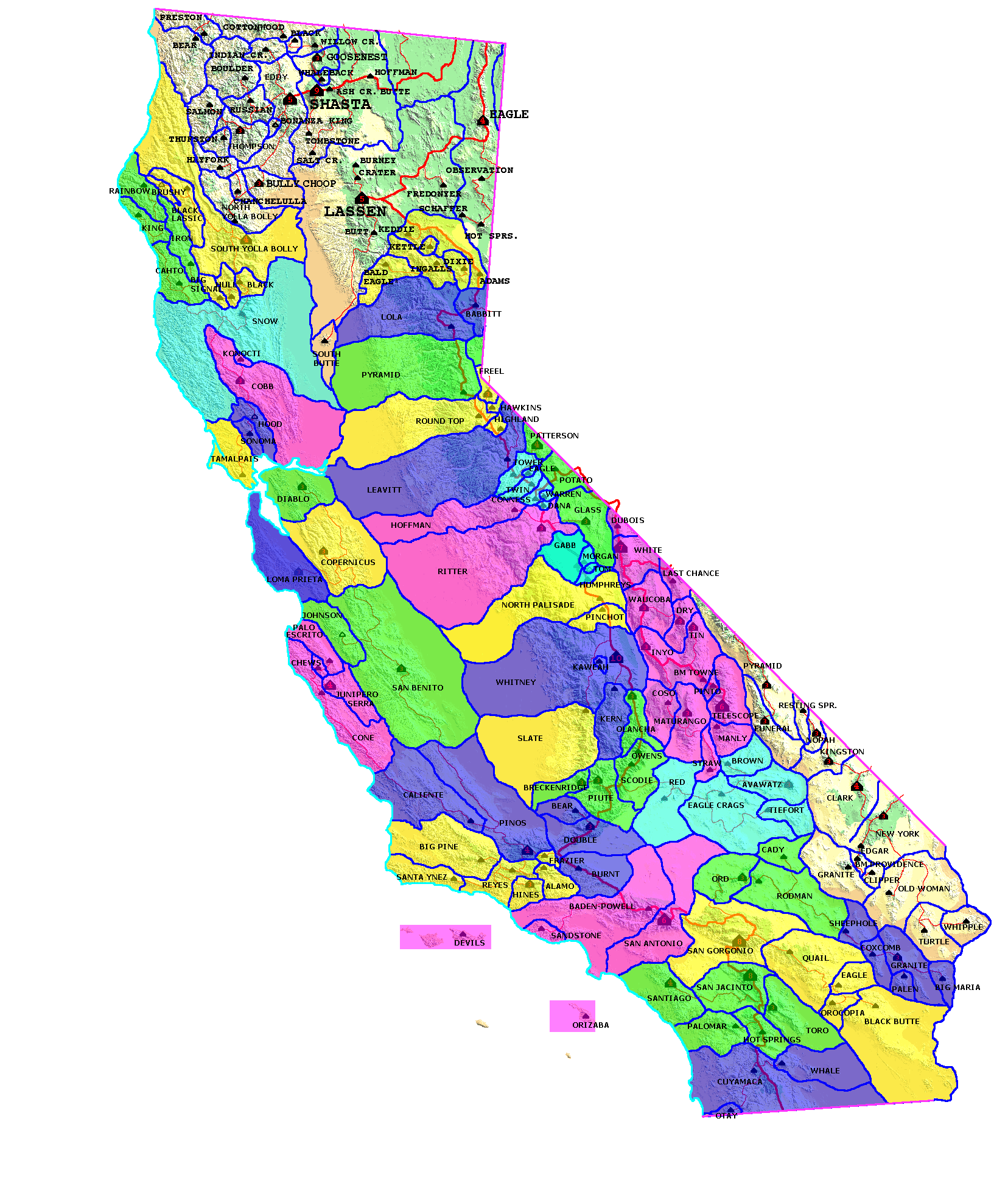
The tables are organized by Lineage Cells. Briefly, there are 163
summits in California with proven prominence of 2,000' and
greater. They are well-distributed across the state's landscape
in all regions. If you just want to look at the major prominences
for the state, then you should go to the P2000 table and the P2000 map. A
separate California introduction
page also compares the concepts of P5000, P2000, and P500.
Each of the 163 summits has a group of summits in its environs that
form a contiguous group. A Cell
Reference Map provides a visual clue as to their shapes and
locations. The groups are defined by a non-arbitary set of rules
that are fully discussed in the theory
section of this website. It is important to note that these
groups do not necessarily represent a discreet place-name or mountain
range, they are based purely on the shape of the terrain.
Cells vary wildly in size. Several P2000 summits have no
subsidiary summits in their group. These "monotypic" peaks such
as Frazier Mtn. in Ventura County, and Shaffer Mtn., in Lassen County
have little relief on their slopes above the contour at their nearby
key saddle. At the other extreme, Mt. Whitney, North Palisade,
Leavitt Peak in the Southern Sierra, and Snow Mtn., in the North Coast
Ranges have over 100 subsidiary peaks in their cell. It is not
surprising
perhaps that different geomorphological regions have different average
numbers of subsidiary peaks in their cells. The Southern Sierra
has extremely rugged terrain that result in numerous sub-peaks, but
very few low passes that would create multiple cells. The average
cell has 23 peaks.
Rank and
Selection
Criteria:
Each table ranks
the summits in descending order by prominence.
IMPORTANT:
My criterion for inclusion on this list is that a summit must have an expected prominence of 500'
or more, given the contour intervals of the summit and saddle.
This means that a summit with 480' of clean prominence and a 40'
contour interval will be included on the list. A summit with 440'
of clean prominence and combined summit and saddle contour intervals of
80' will not be included on the list. In this case the possible
prominence values range from 440' to 520', and therefore the peak could
be said to have a 25% probability of being a ≥500' prominence (using a
linear distribution model). As the peak only has an expected
prominence of
480' it is not included. The rationale is to
avoid the multiplicity of mostly unnamed peaks that have a low
probability of acheiving 500' promiennce. Given 80' combined
contour intervals, 480+80 is always included and 440+80 is never
included. I welcome additions of peaks that are estimated
to have a prominence of ≥500' after site investigations.
Summit
Names:
As a default
measure, summits on this table are as they appear on the USGS 7.5'
topographic maps. In subsequent revisions of the Atlas I hope to
add many unofficial names and to correct USBGN
names that are omitted or are otherwise inaccurate on the 7.5'
maps. Peaks in quotation marks are non-official names.
Following is the preferred hierarchy for place names in descending
order of preference:
USBGN official place name for a mountain
or summit whether or not
the name appears on the 7.5' topographic map.
Unoffficial name for a mountain or summit
that is in common usage
in the hiking community or otherwise. The name appears in the
table in quotations.
Name of a nearby named peak if the
highpoint is functionally on
the same summit block or plateau. In many cases, a well-known
named peak is slightly lower than a higher point nearby (but often less
visible from below), c.f. Glass Mountain. The place name will be
employed where the named point and the high point are not separated by
a low saddle and are one mile or less apart. These are denoted in
the tables as "nr."
Name of an official (USGS or NGS)
benchmark. In most cases
the benchmark will be noted and named on the 7.5' map. These are
denoted in the tables as "BM".
Name of the mountain range if the peak is
the high point of that
range and does not merit its own BM. This is a frequent occurance
in desert ranges. The peak will be denoted as "HP", such as "HP
Arica Mtns."
The spot elevation provided on the 7.5'
map, where no place name
is known. In most cases this will be denoted as "Pt." such as
"Pt. 3083". In some cases in the High Sierra, where R.J. Secor
confirms that there is no known summit name, I denote the table as "Pk.
12530", to signify that this is the 'working name' for the peak.
Values from metric 7.5' maps are denoted with an "M", such as "Pt.
3581m" to signify a peak of 11,749' elevation marked on the topographic
map with a spot elevation of 3,581 meters.
Where no spot elevation is provided, I
use the highest
contour. For example a peak marked "Pt. 8560+" would be a summit
whose highest contour was 8,560', but whose actual elevation is between
8,560' and the next higher contour (generally 40' in mountainous areas.)
Elevations:
For the first version of the Atlas, the vast majority of elevations are
taken directly from the USGS 7.5' maps.
In many cases, I have used the GNIS elevation if the following three
conditions are met: 1.) A spot elevation is omitted from
the USGS map. 2.) The value provided by GNIS is within the
contour interval stated on the topographic map. 3.) We do
not have any other secondary source of spot elevation information, such
as benchmark data, or elevations provided on smaller-scale topographic
maps. GNIS is notoriously inaccurate. Elevations are often
wrong by hundreds of feet. I feel that the above conditions
improve the overall quality of the data; because inclusion of the GNIS
data in these instances often compensates for simple errors of on the
USGS map. I ignore GNIS entirely if it is out of the bounds of
the topographic contour.
All of the elevations on the USGS maps are from the superceded NGVD29
vertical datum. This system, based on an earlier conception of
the geoid model should be considered obsolete. Modern elevations
are based on a different methodology, developed in 1988, and on a much
more sophisticated geoid model. Analysis of the two systems is
beyond the scope of this page, but perhaps I will write a later article
for the theory section. Modern elevations, using the NAVD88
vertical datum and GEOID03, will typically differ between -5' and +15'
from the printed elevations.
In cases where I have used NGS data to supplement elevation information
in the atlas, I always quote the superceded survey data, based on the
most recent application of NGVD29 found on the benchmark
tearsheets. This is so as to compare "apples and apples".
Prominence data, of course, needs to employ the same datum for both
summit and saddle to maximize accuracy.