email webmaster for more information
Skip down to the introduction to P2000s, the P1000s, the P500s
Skip down to the following
Group: Charleston,
Eddy, Lassen, Piños, Shasta, Southern California,
Telescope-White, Whitney.
About the Mountain Atlas:
The California Mountain Atlas is a compendium of all summits in the state with 500' of prominence. This Atlas lists 4,106 summits (as of 6/25/06).In order to appreciate the work in this atlas it helps to understand a few key concepts about topographic prominence and orometry. The data is organized in a logical manner that takes some getting used to. All mountains referenced in these pages include a precise name, elevation, prominence, and coordinate. Lists are organized by orometric groups, and by lineage cell. Most lists are further sorted by prominence value. None of these concepts are particularly hard to grasp, but it can seem a bit counter-intuitive first. Prominence and orometric groupings are purely geographical functions, so you will not find many lists in these pages sorted by political subdivision.
If you have difficulty navigating this site, I suggest you do three things: 1) Look at the California Introduction Page, which describes the different sets of mountains based on prominence cutoffs, 2) take a few minutes to familiarize yourself with the 167 lineage cells by examining the graphical map of the Lineage cells, and 3) read the theory section of Peaklist.
The California P2000s: "eagles"
Cailfornia has 163 summits with 2000' of clean prominence, which represent an interesting assortment of hiking challenges that are well-distributed across the different geographies of the state.
In 2002, I researched and completed the first listing of the California P2000s. This was based on extensive prior research by Andy Martin (for the Top 50) and Edward Earl. In 2003 this project was extended to include all of the United States. Information about the 1234 US P2000 summits is on the US P2000 homepage.
It is important to orient yourself to the California P2000s by way of understanding the organization of the California Mountain Atlas.
Several hikers are making significant progress toward hiking all of the summits on the list (7 are more than half way). You can track your own progress by registering (free) at listsofjohn.com, and track the leaders on the Prominence Front Runner List.
The California P1000s: "half eagles"
California has 972 summits with 1000' of clean prominence. I have created custom lists and maps for the P1000s, which are separated by lineage group, similar to the P500s below.
The California P500s
Data Summary:
There are 4106 summits in California with 500' or more of interpolated prominence (error range peaks with less than 500' of interpolated prominence are not tracked). This atlas provides lists and maps to all of the summits.
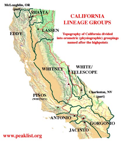
Organization of this data is based on two divisions for ease of use: Firstly, the data is organized around eight groups of summits, each named after their highpoint (Southern California is grouped together.) The map on the right should serve as a guide.
Secondly, the lists of P500s all derive from the P2000 Lineage Cell. Every P2000 summit (167) has a specific lineage area of lesser summits around it. This is based on some non-arbitrary rules that are described in the theory section. It is really not necessary to understand the theory - take a look at some of the cell maps (generated with Topo! software) for a visual understanding of the hierarchical organization.
Within each lineage cell below, I have listed the number of corresponding summits with 500' prominence or greater, and the links to the corresponding maps.
The Eight Groups:
Because of the peculiar geography of California
these groupings
are largely intuitive. Eddy and Piños represent the Coast
Ranges north
and south of San Francisco Bay. Lassen and Shasta comprise the
northeast corner of the state including the Cascades, the Warners and
the northern end of the Sierra north of the Feather River.
Virtually
the entire Sierra Nevada is included under Whitney, which also includes
a few Trans-Sierra and High Desert Ranges. White/Telescope
includes
the Inyo, Panamints, and other Trans-Sierra ranges west of Death
Valley. Gorgonio on the list below includes Antonio and Jacinto -
i.e. all of Southern California.- Charleston and Jefferson Group these are the California fragments of the lineage for Charleston Peak, NV and Mt. Jefferson, NV. This includes all ranges east of Death Valley and in the east Mojave.
- Eddy Group: Coast ranges north of San Francisco Bay and West of I-5 to the Oregon Border
- Gorgonio Group:
The combined lineage areas for San Gorgonio, San Jacinto and San
Antonio Mtns.,
including all of Southern California south of Soledad Pass (Antelope
Freeway.)
- Lassen Group: The Northernmost edge of the Sierra - north of Beckwourth Pass, the Lassen region and the Warner Mtns., and basin and range country of extreme Northeastern CA.
- Piños Group: The Coast Ranges south of San Francisco Bay to Soledad Pass, and including the Tehachapi Mtns. as far as Tehachapi Pass.
- Shasta Group: East of I-5 and NW of the Pit River, a comparatively small area.
- White/Telescope Groups High desert ranges east of the Owens Valley and west of Death Valley., particularly the Inyo Mountains and the Panamint Range.
- Whitney Group: The entire Sierra Nevada south of Beckwourth Pass and north of Tehachapi Pass. Group also includes Trans-Sierra ranges (east of US-395 and west of CA-6) and a large section of the High Mojave around China Lake and the Avawatz Mtns.
Piños Group
Group
Finished - Dec.
23, 2003: 504 mountains
The Coast ranges south from San Francisco Bay to Tehachapi Pass and Soledad Pass. To find a mountain in the Coast Ranges first identify a Lineage Group on the California Lineage Cell Map. Then click on the name of the lineage cell below for the table, or to the right for a Topo! generated lineage map. Click here for the California Lineage Cell Guide Map.
| ALAMO |
11 |
see Reyes Map |
| BEAR |
5 |
see Piños Map |
| BIG
PINE |
58 |
MAP ONLINE |
| BURNT/LIEBRE |
26 |
see Piños Map |
| CALIENTE |
52 |
MAP
ONLINE |
| CHEWS |
24 | see Junipero Map |
| CONE |
37 |
see Junipero Map |
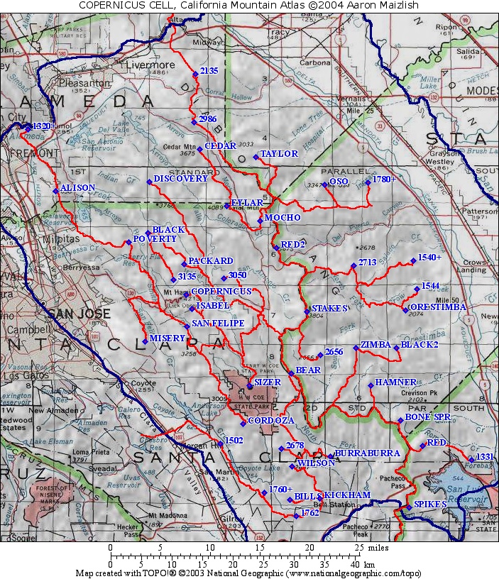
| COPERNICUS |
44 |
MAP ONLINE |
| (DEVILS) -
Northern Channel Is. |
7 |
MAP
ONLINE |
| DIABLO |
18 |
MAP ONLINE |
| DOUBLE |
17 | see Piños Map |
| FRAZIER |
1 |
see Piños Map |
| HINES |
8 |
see Reyes Map |
| JOHNSON |
14 |
see San Benito Map |
| JUNIPERO
SERRA |
14 |
MAP ONLINE |
| LOMA
PRIETA |
23 |
MAP ONLINE |
| (ORIZABA) - Southern Channel Is. |
7 |
MAP ONLINE |
| PALO
ESCRITO |
8 |
see Junipero Map |
| PIÑOS |
19 |
MAP ONLINE |
| REYES |
19 |
MAP ONLINE |
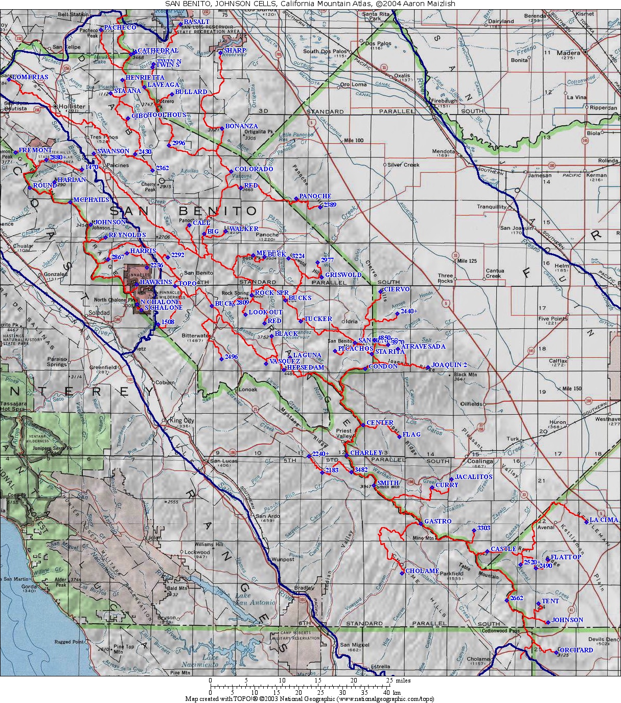
| SAN
BENITO |
77 |
MAP
ONLINE |
| SANTA
YNEZ |
11 | see Big Pine Map |
Southern
California Groups (San
Gorgonio, San Antonio, San Jacinto)
Group
Finished - January 21, 2004: 635
mountains
The Southern California Groups include California mountains in the P5000 cells of San Antonio, San Gorgonio, and San Jacinto. This comprises everything south of Soledad Pass (the Antelope Freeway) near Palmdale, including many desert ranges in the low Mojave and Colorado Deserts. The cells average 27 peaks each.
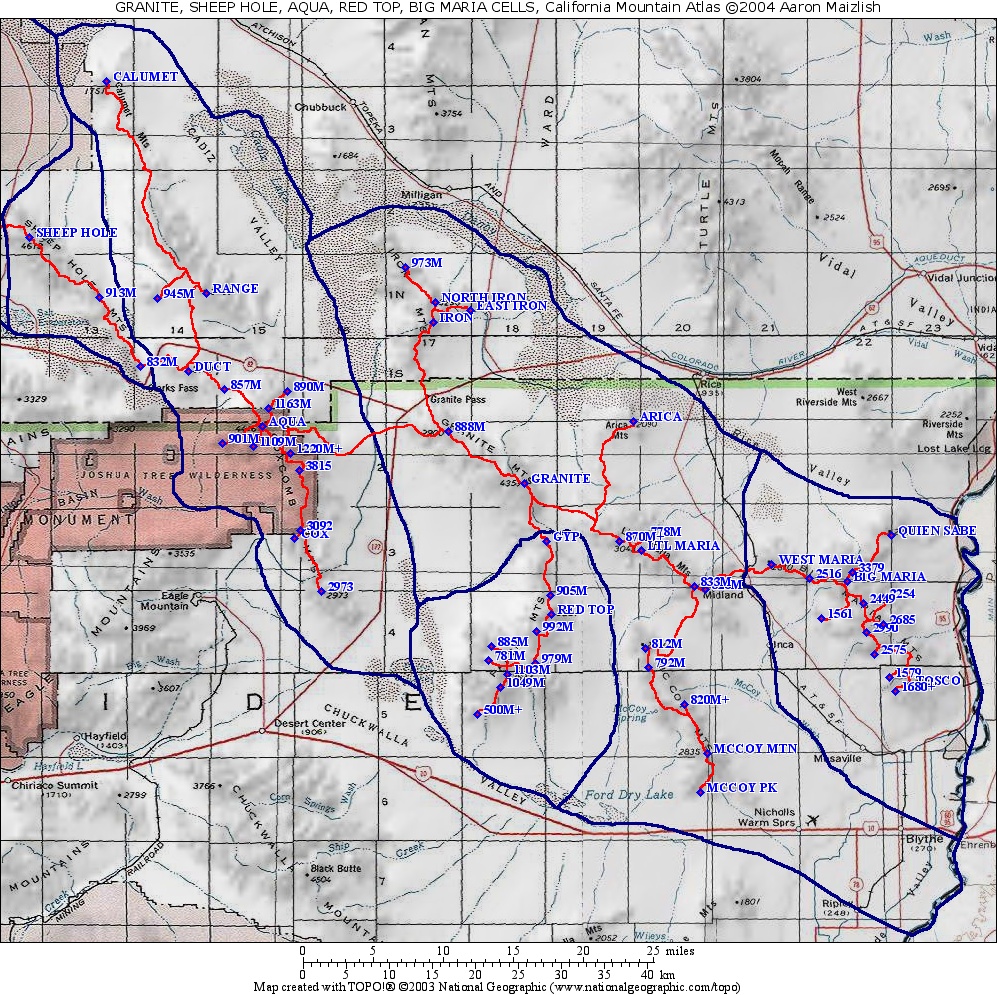
| AQUA (COXCOMB) | 15 |
see Granite Map |
| BADEN-POWELL |
60 |
MAP
ONLINE |
| BIG
MARIA |
14 |
see Granite Map |
| BLACK
BUTTE (Gorgonio) |
67 |
MAP
ONLINE |
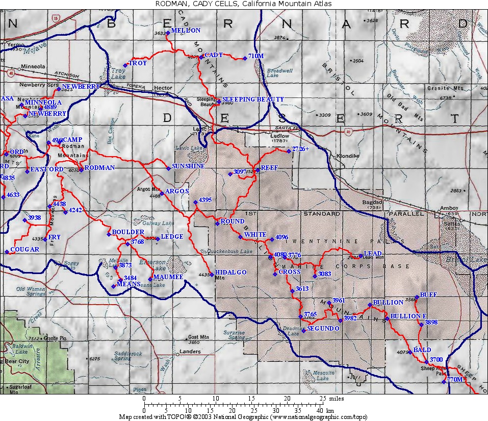
| CADY |
5 |
see Rodman Map |
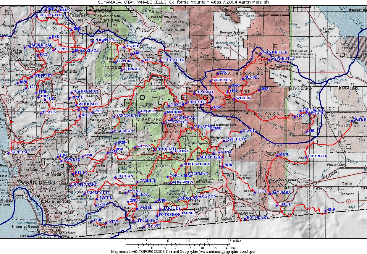
| CUYAMACA |
89 | MAP
ONLINE |
| EAGLE |
10 |
see Quail Map |
| GRANITE |
17 | MAP ONLINE |
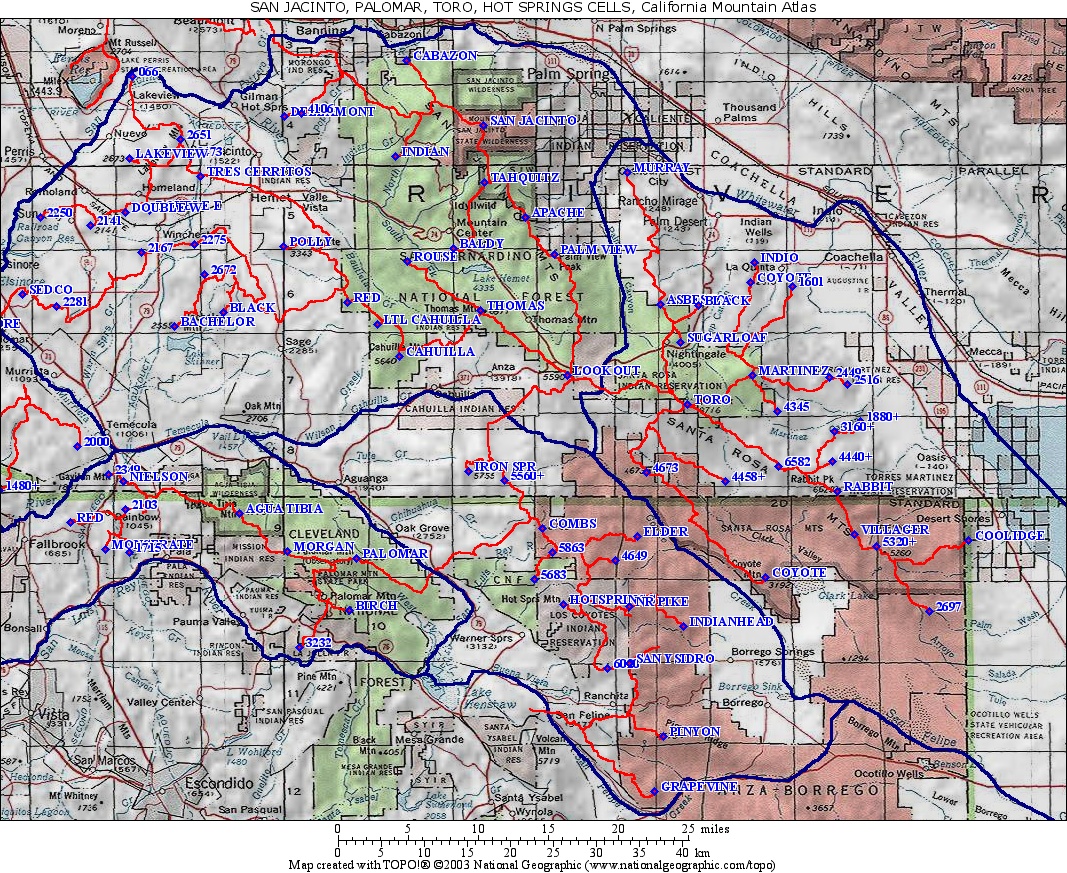
| HOT
SPRINGS |
15 |
see San Jacinto Map |
| ORD |
34 |
MAP
ONLINE |
| OROCOPIA |
4 |
see Black Butte Map |
| OTAY |
2 |
see Cuyamaca Map |
| PALOMAR |
11 |
see San Jacinto Map |
| QUAIL |
34 |
MAP ONLINE |
| RED TOP (PALEN) | 10 |
see Granite Map |
| RODMAN |
42 |
MAP ONLINE |
| SAN
ANTONIO (BALDY) |
34 |
MAP
ONLINE |
| SAN
GORGONIO |
69 |
MAP ONLINE |
| SAN
JACINTO |
34 |
MAP ONLINE |
| SANDSTONE | 11 |
see Baden-Powell Map |
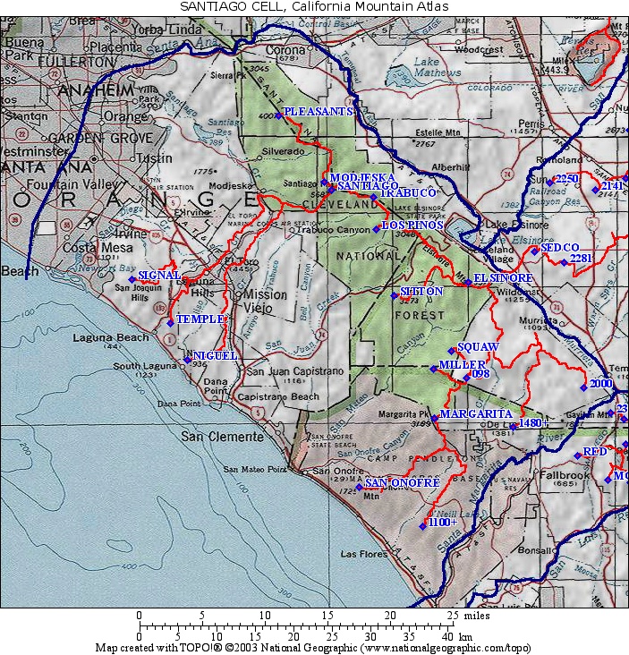
| SANTIAGO |
18 |
MAP ONLINE |
| SHEEP
HOLE |
3 |
see Granite Map |
| TORO |
24 |
see San Jacinto Map |
| WHALE |
16 | see Cuyamaca Map |
Whitney Group
Group
Finished - December 10, 2004: 1184
mountains
This group includes the Sierra Nevada from Beckwourth Pass south to Tehachapi Pass, including the trans-Sierra ranges, bounded on the East by Owens Valley, plus some of the High Mojave near China Lake and the Avawatz Mtns.
The Mt. Whitney P2000 Lineage Cell is monstrous, with 187 peaks. I have no idea why the highest peak gets the most P500s in its cell - its a peculiarity specific to the landform of the Southern Sierra.
In future revisions I hope to add some of the data not on the USGS 7.5' maps, such as unofficial names provided by RJ Secor and others, and additional spot elevations. Help from a Sierra buff would be appreciated.
Cells marked (Mojave) and (Trans) are not in the Sierra proper (see guide map above) all other cells are.
| AVAWATZ (Mojave) | 50 |
|
| BABBITT |
15 |
see Lola Map |
| BRECKENRIDGE |
2 |
see Piute Map |
| BROWN (Mojave) | 9 |
|
| CONNESS |
12 |
MAP ONLINE |
| DANA |
3 |
see Conness Map |
| EAGLE |
3 |
see Conness Map |
| EAGLE CRAGS (Mojave) | 21 |
MAP
ONLINE |
| FREEL |
6 |
see Round Top Map |
| GABB or
BEAR CREEK |
59 | see Humphreys Map |
| GLASS (Trans-Sierra) | 13 |
see Patterson Map |
| HAWKINS |
3 |
see Round Top Map |
| HIGHLAND |
9 | see Round Top Map |
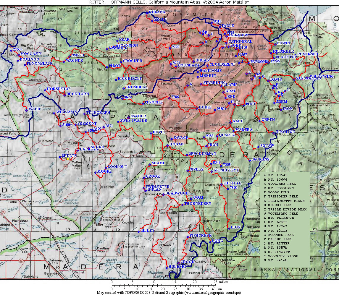
| HOFFMANN |
27 |
see Ritter Map |
| HUMPHREYS |
6 |
MAP
ONLINE |
| KAWEAH |
6 |
see Whitney map |
| KERN |
44 |
MAP ONLINE |
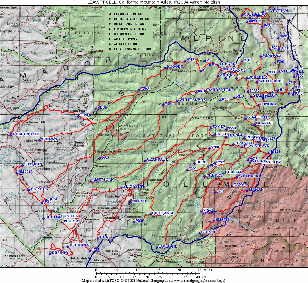
| LEAVITT |
101 | MAP
ONLINE |
| LOLA |
76 |
MAP
ONLINE |
| MORGAN |
3 |
see Humphreys
Map |
| NORTH
PALISADE |
130 |
MAP ONLINE |
| OLANCHA |
25 |
MAP
ONLINE |
| OWENS |
17 |
see Olancha Map |
| PATTERSON (Trans-Sierra) |
4 |
MAP
ONLINE |
| PINCHOT |
11 |
see Palisade Map |
| PIUTE |
29 |
MAP
ONLINE |
| POTATO (Trans-Sierra) | 6 |
see Patterson Map |
| PYRAMID |
48 |
MAP ONLINE |
| RED
(Mojave) |
11 |
see Eagle Crags Map |
| RITTER |
95 | MAP
ONLINE |
| ROSE,
NV |
3 |
see Pyramid Map |
| ROUND
TOP |
18 |
MAP
ONLINE |
| SCODIE |
18 |
see Piute Map |
| SLATE |
39 |
MAP ONLINE |
| TIEFORT (Mojave) | 18 |
|
| TOWER |
24 |
see Conness Map |
| TWIN |
27 |
see Conness Map |
| WARREN |
4 |
see Conness Map |
| WHITNEY |
187 |
MAP
ONLINE! |
| GRANT, NV |
2 |
see Patterson Map |
White Mountain and Telescope Groups
Group
Finished - Dec.
12, 2003: 184 mountains
The area East of Owens Valley and West of Death Valley,
proceeding
North to
South, including the White Mountains, Inyo Mountains and Panamint
Range, among others.| COSO |
27 |
|
| DRY |
16 |
|
| DUBOIS |
5 |
see White Mtn. Map |
| KEYNOT (or INYO) |
22 |
|
| MANLY |
12 |
|
| MATURANGO |
4 |
|
| PINTO | 1 |
|
| STRAW |
4 |
|
| TELESCOPE |
20 |
|
| TIN |
13 |
|
| TOWNE |
3 |
|
| WAUCOBA |
31 |
|
| WHITE
MOUNTAIN |
20 |
MAP
ONLINE |
Lassen Group
Group
Finished - Dec. 5, 2004: 286
mountains
The Lassen group includes most of Northeastern California,
except the Shasta Region. On the West side, the group extends
from
the Pit River, south to Lake Shasta and down the Sacramento
River. On the southern side, the border starts at Beckwourth Pass
(the Mt. Lassen KS) and goes down the Middle Fork of the
Feather River to the Sacramento Delta. This group include the
Sutter Buttes. On the East Side, the
group includes Modoc and Lassen Counties. Logically extended, the
Lassen Group would continue into Nevada, and include all of Central and
Southeastern Oregon.| ADAMS |
26 |
|
| BALD
EAGLE |
14 |
|
| BURNEY |
3 |
|
| BUTT |
16 |
|
| CRATER |
33 |
|
| DIXIE |
12 |
|
| EAGLE |
23 |
|
| INGALLS |
11 |
|
| FREDONYER |
9 |
|
| HOT
SPRINGS |
5 |
|
| KEDDIE |
8 |
|
| BM KETTLE |
5 |
|
| LASSEN |
95 |
|
| OBSERVATION |
7 |
|
| SHAFFER |
1 |
|
| SOUTH
BUTTE |
5 |
|
| CRANE,
OR
(partial) |
4 |
|
| GEARHART,
OR
(partial) |
7 |
|
| PETERSEN,
NV
(partial) |
1 |
|
| STATE
LINE,
NV (partial) |
1 |
Shasta Group
Group
Finished - Feb. 5, 2004: 137
mountains
The Shasta group is a smallish
region of Northern California around Mt. Shasta to the Oregon
border. The area is bounded on the west by the Sacramento
River and I-5, on the north by the Klamath River, and on the south by
the Pit River and Lake Shasta. The area is mostly volcanic, with
a few areas of high-density summits especially in the foothills north
of Lake Shasta and to the east of Mt. Shasta. Because of the
frequency of prominent cinder cones north of Mt. Shasta, there are
several small cells in the region.
| ASH CREEK BUTTE | 9 |
available |
| BLACK |
3 |
available |
| GOOSENEST |
6 |
available |
| HOFFMAN |
66 |
available |
| SALT CREEK | 6 |
available |
| SHASTA |
7 |
available |
| TOMBSTONE | 22 | available |
| WHALEBACK |
4 |
available |
| WILLOW CREEK | 12 |
available |
| HAMAKER, OR (partial) | 2 |
available |
Charleston, NV and Jefferson, NV Groups (partial)
Group
Finished January 25, 2005: 295
mountains
The Eastern Mojave and ranges north and east of Death Valley.
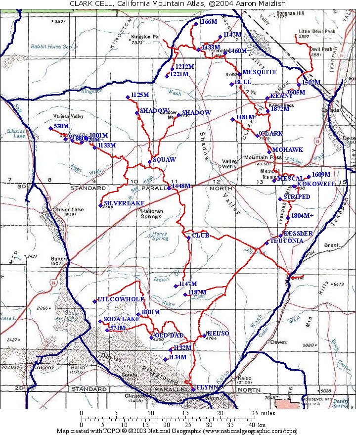
CHARLESTON GROUP |
||
| CLARK | 45 |
MAP
ONLINE |
| CLIPPER | 4 |
see Edgar Map |
| EDGAR | 4 |
MAP ONLINE |
| GRANITE | 26 |
see Edgar Map |
| KINGSTON | 17 |
MAP ONLINE |
| NEW YORK | 12 |
MAP ONLINE |
| NOPAH | 6 |
see Kingston Map |
| OLD WOMAN | 42 | MAP
ONLINE |
| PROVIDENCE | 2 |
see Edgar Map |
| RESTING SPRING | 8 |
see Kingston Map |
| TURTLE | 30 |
see Old Woman Map |
| WHIPPLE | 23 |
see Old Woman Map |
| MCCULLOUGH,
NV |
6 |
see
New York
Map |
| SPIRIT,
NV |
2 |
see
New York
Map |
JEFFERSON GROUP |
||
| FUNERAL |
30 |
see
Pyramid
Map |
| PYRAMID | 11 |
MAP ONLINE |
| BLUE DICK, NV | 4 |
see Last Chance Map |
| GRAPEVINE,
NV |
20 |
see
Pyramid
Map |
| LAST CHANCE |
3 | MAP
ONLINE |
Eddy Group
Group
Finished - June 25, 2006: 888
mountains
The Eddy Group includes the Coast Ranges west of Interstate 5 from near the Oregon Border to the San Francisco Bay. Included at the end of this set are the cells north of the Klamath River (McLoughlin, OR Group).
| BIG SIGNAL |
6 |
|
| BLACK
BUTTE |
6 |
|
| BLACK
LASSIC |
16 |
|
| BONANZA KING |
3 |
see Eddy Map |
| BOULDER | 49 | |
| BRUSHY | 2 |
|
| BULLY CHOOP |
15 |
MAP
ONLINE |
| CAHTO | 23 |
|
| CHANCHELULLA |
9 |
see Bully Choop Map |
| COBB | 73 |
MAP ONLINE |
| EDDY | 51 |
MAP ONLINE |
| HAYFORK
BALLY |
17 |
see Bully Choop Map |
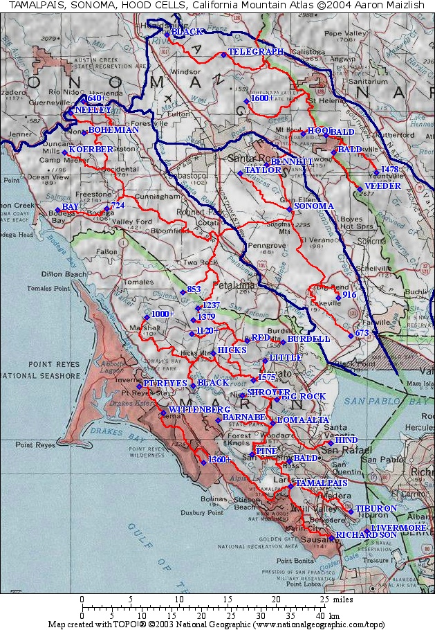
| HOOD |
8 |
see Tamalpais Map |
| HULL |
3 |
|
| INDIAN
CREEK |
15 |
MAP ONLINE |
| IRON |
27 |
|
| KING |
17 |
|
| KONOCTI | 1 |
see Cobb Map |
| NORTH
YOLLA BOLLY |
23 |
see Bully Choop Map |
| RAINBOW |
24 |
|
| RUSSIAN | 32 |
|
| SALMON |
26 |
|
| SNOW |
146 |
|
| SONOMA | 4 |
see Tamalpais Map |
| SOUTH
YOLLA BOLLY (LINN) |
88 |
|
| TAMALPAIS |
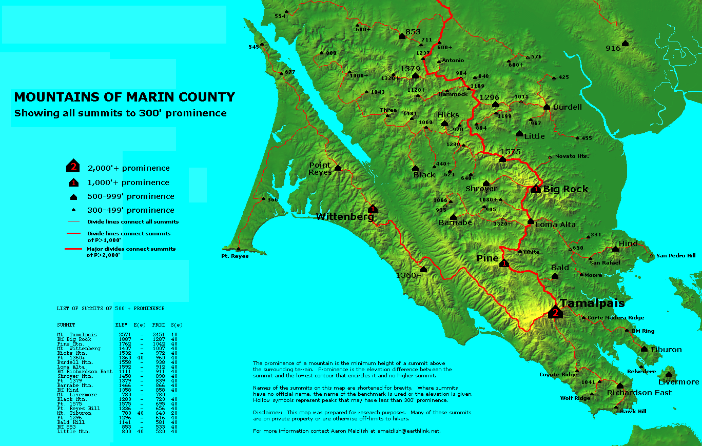
31 | Map Online (standard) Marin Map (P300s) |
| THOMPSON |
46 |
|
| THURSTON |
16 |
|
MCLAUGHLIN, OR Group (fragment)
|
||
| BEAR |
48 | |
| PRESTON | 19 |
|
| COTTONWOOD | 4 |
|
| ASHLAND, OR | 9 |
|
| GRAYBACK, OR | 12 |
|
| PEARSOLL, OR | 9 |
|