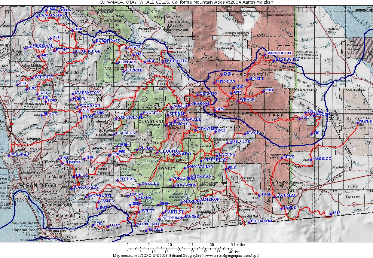
| California Cell Reference Map |
California
Mountain
Atlas Home Page |
Peaklist Home Page |
Notes
and Key to California Mountain Atlas |
| RANK | SUMMIT NAME | ELEV. | E(e) | PROM. | SADDLE | S(e) | Lat. | Long. |
| 1 | Whale Peak | 5349 | 2700 | 2649 | 33º01'46"N | 116º18'58"W | ||
| 2 | BM Eagle | 2371 | 1611 | 760 | 40 | 32º58'41"N | 116º00'07"W | |
| 3 | Sunset Mtn. | 3657 | 1057 | 2600 | 40 | 33º06'09"N | 116º16'39"W | |
| 4 | Pt. 3583 | 3583 | 783 | 2800 | 40 | 33º03'49"N | 116º12'35"W | |
| 5 | Pt. 2181 | 2181 | 701 | 1480 | 40 | 32º59'21"N | 116º02'18"W | |
| 6 | Pt. 3567 | 3567 | 687 | 2880 | 40 | 33º04'28"N | 116º19'48"W | |
| 7 | Pt. 2860 | 2860 | 660 | 2200 | 40 | 33º07'14"N | 116º22'51"W | |
| 8 | Pt. 2121 | 2121 | 601 | 1520 | 40 | 32º58'07"N | 116º03'44"W | |
| 9 | Pt. 1401 | 1401 | 601 | 800 | 40 | 32º54'55"N | 116º00'46"W | |
| 10 | BM Fish | 2334 | 594 | 1740 | 20 | 32º58'54"N | 115º58'51"W | |
| 11 | Pt. 3459 | 3459 | 579 | 2880 | 40 | 32º59'53"N | 116º24'33"W | |
| 12 | HP N. Pinyon Mts. | 3640 | 40 | 560 | 3080 | 40 | 33º05'38"N | 116º24'39"W |
| 13 | Pt. 2120+ | 2120 | 40 | 560 | 1560 | 40 | 32º59'08"N | 116º00'50"W |
| 14 | East Butte | 1196 | 516 | 680 | 40 | 33º10'11"N | 116º10'05"W | |
| 15 | Pt. 4492 | 4492 | 492 | 4000 | 40 | 33º03'23"N | 116º20'28"W | |
| 16 | West Butte | 1207 | 487 | 720 | 40 | 33º11'28"N | 116º12'15"W | |