
| 0back to PEAKLIST LISTS AND MAPS PAGE |
go to WORLD ULTRAS PAGE |
back to PEAKLIST HOME PAGE |
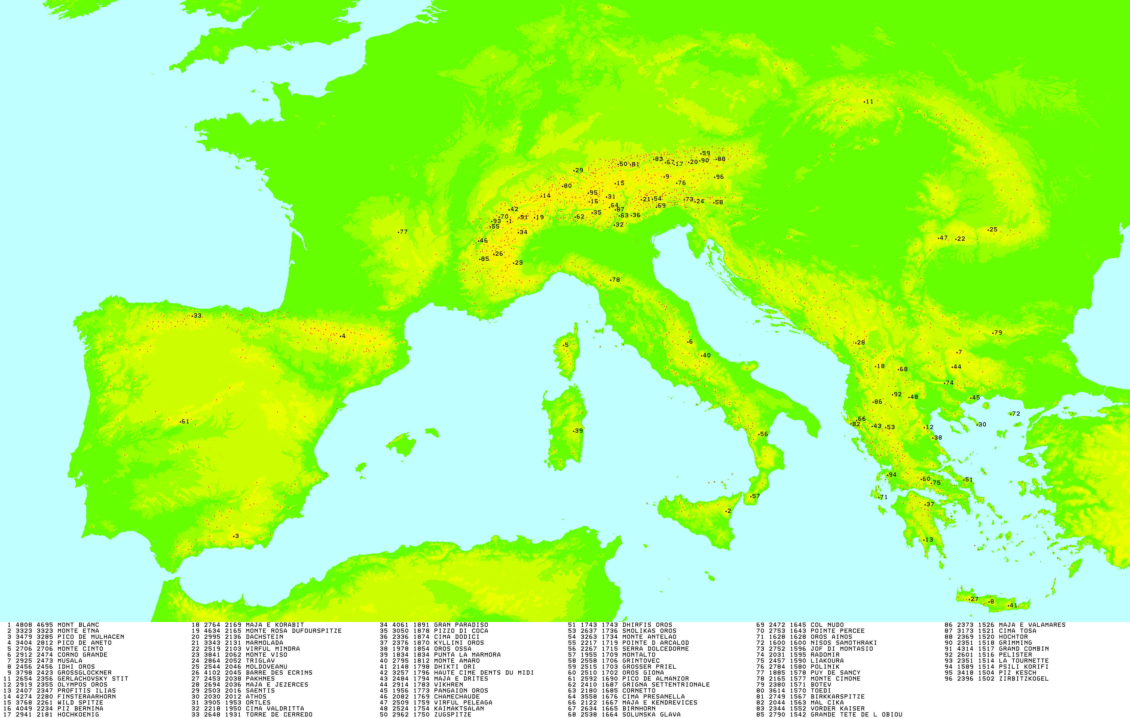
| Rank | Summit Name | Country | Elevation (m) |
Prominence (m) |
Saddle (m) |
Latitude | Longitude | Elev. (ft) |
Prom. (ft) |
Footnotes |
| 1 | Mont Blanc | France | 4808.75 |
4696 | 113 | 45º49'57"N | 6º51'52"E | 15777 | 15410 | [1] |
| 2 | Monte Etna | Italy (Sicily) |
3323 | 3323 | 0 | 37º45'04"N | 14º59'45"E | 10902 | 10902 | |
| 3 | Pico del Mulhacén | Spain | 3479 | 3285 | 194 | 37º03'16"N | 3º18'36"W | 11414 | 10777 | |
| 4 | Pico de Aneto | Spain | 3404 | 2812 | 592 | 42º37'56"N | 0º39'28"E | 11168 | 9226 | |
| 5 | Monte Cinto | France (Corsica) |
2706 | 2706 | 0 | 42º22'48"N | 8º56'50"E | 8878 | 8878 | |
| 6 | Corno Grande | Italy | 2912 | 2476 | 436 | 42º28'12"N | 13º34'02"E | 9554 | 8123 | |
| 7 | Musala | Bulgaria | 2925 | 2473 | 452 | 42º10'47"N | 23º35'12"E | 9596 | 8113 | |
| 8 | Psiloritis (Timios Stavros) | Greece (Crete) |
2456 | 2456 | 0 | 35º13'36"N | 24º46'21"E | 8058 | 8058 | |
| 9 | Grossglockner | Austria | 3798 | 2423 | 1375 | 47º04'27"N | 12º41'40"E | 12460 | 7949 | |
| 10 | Galdhøpiggen | Norway | 2469 | 2372 | 97 | 61º38'12"N | 8º18'54"E | 8100 | 7782 | |
| 11 | Olympos Oros (Mytikas) | Greece | 2919 | 2355 | 564 | 40º04'58"N | 22º21'04"E | 9576 | 7726 | [11] |
| 12 | Gerlach / Gerlachovsky Stít | Slovakia | 2655 | 2355 | 300 | 49º09'51"N | 20º08'09"E | 8709 | 7726 | |
| 13 | Profitis Ilias (HP Taygetos) |
Greece | 2404 | 2344 | 60 | 36º57'14"N | 22º21'08"E | 7887 | 7690 | [13] |
| 14 | Finsteraarhorn | Switzerland | 4274 | 2280 | 1994 | 46º32'14"N | 8º07'34"E | 14022 | 7480 | |
| 15 | Wildspitze | Austria | 3768 | 2261 | 1507 | 46º53'07"N | 10º52'02"E | 12362 | 7418 | |
| 16 | Piz Bernina | Switzerland | 4049 | 2234 | 1815 | 46º22'56"N | 9º54'29"E | 13284 | 7329 | [16] |
| 17 | Hochkönig | Austria | 2941 | 2181 | 760 | 47º25'13"N | 13º03'45"E | 9649 | 7155 | |
| 18 | Golem Korab / Maja e Korabit | Albania/Macedonia | 2764 | 2169 | 595 | 41º47'28"N | 20º32'52"E | 9068 | 7116 | |
| 19 | Monte Rosa (Dufourspitze) | Switzerland | 4634 | 2165 | 2469 | 45º56'13"N | 7º52'01"E | 15203 | 7103 | |
| 20 | Hoher Dachstein | Austria | 2995 | 2136 | 859 | 47º28'31"N | 13º36'23"E | 9826 | 7008 | |
| 21 | Marmolada | Italy | 3343 | 2131 | 1212 | 46º26'05"N | 11º51'03"E | 10968 | 6991 | |
| 22 | Parîngul Mare | Romania | 2519 | 2103 | 416 | 45º20'28"N | 23º32'26"E | 8264 | 6900 | [22] |
| 23 | Monte Viso | Italy | 3841 | 2062 | 1779 | 44º40'03"N | 7º05'27"E | 12602 | 6765 | |
| 24 | Triglav | Slovenia | 2864 | 2052 | 812 | 46º22'41"N | 13º50'13"E | 9396 | 6732 | |
| 25 | Varful Moldoveanu | Romania | 2544 | 2046 | 498 | 45º36'00"N | 24º44'16"E | 8346 | 6713 | |
| 26 | Barre des Écrins | France | 4102 | 2045 | 2057 | 44º55'21"N | 6º21'36"E | 13458 | 6709 | |
| 27 | Pakhnes | Greece (Crete) |
2453 | 2038 | 415 | 35º17'33"N | 24º02'00"E | 8048 | 6686 | |
| 28 | Maja e Jezercës | Albania | 2694 | 2036 | 658 | 42º26'33"N | 19º48'51"E | 8838 | 6680 | [28] |
| 29 | Säntis | Switzerland | 2503 | 2021 | 482 | 47º14'58"N | 9º20'36"E | 8212 | 6630 | |
| 30 | Athos / Ormos Vatopediou | Greece | 2030 | 2012 | 18 | 40º09'32"N | 24º19'42"E | 6660 | 6601 | [30] |
| 31 | Ortler / Ortlés | Italy | 3905 | 1953 | 1952 | 46º30'32"N | 10º32'41"E | 12812 | 6407 | |
| 32 | Olympos | Cyprus | 1952 | 1952 | 0 | 34º56'18"N | 32º51'40"E | 6404 | 6404 | [32] |
| 33 | Monte Baldo (Cima Valdritta) | Italy | 2218 | 1950 | 268 | 45º43'35"N | 10º50'38"E | 7277 | 6398 | |
| 34 | Torre de Cerredo | Spain | 2648 | 1931 | 717 | 43º11'53"N | 4º51'04"W | 8688 | 6335 | |
| 35 | Gran Paradiso | Italy | 4061 | 1891 | 2170 | 45º31'05"N | 7º16'02"E | 13323 | 6204 | |
| 36 | Pizzo di Coca | Italy | 3050 | 1878 | 1172 | 46º04'18"N | 10º00'41"E | 10006 | 6161 | |
| 37 | Cima Dodici | Italy | 2336 | 1874 | 462 | 45º59'51"N | 11º28'05"E | 7664 | 6148 | |
| 38 | Killini Oros | Greece | 2376 | 1870 | 506 | 37º56'23"N | 22º23'49"E | 7795 | 6135 | |
| 39 | Oros Ossa (Kissavos) |
Greece | 1978 | 1854 | 124 | 39º47'49"N | 22º41'13"E | 6489 | 6083 | |
| 40 | La Marmora | Italy (Sardinia) |
1834 | 1834 | 0 | 39º59'17"N |
9º19'27"E |
6017 | 6017 | |
| 41 | Monte Amaro | Italy | 2795 | 1812 | 983 | 42º05'13"N | 14º05'15"E | 9170 | 5945 | |
| 42 | Spathi / Lasithiotika | Greece (Crete) |
2148 | 1798 | 350 | 35º07'08"N | 25º29'56"E | 7047 | 5899 | |
| 43 | Haute Cime: Dents du Midi | Switzerland | 3257 | 1796 | 1461 | 46º09'40"N | 6º55'24"E | 10686 | 5892 | |
| 44 | Nemerçka / Maja e Drites | Albania | 2482 | 1792 | 690 | 40º07'29"N | 20º26'03"E | 8144 | 5880 | |
| 45 | Vikhren | Bulgaria | 2914 | 1783 | 1131 | 41º46'04"N | 23º24'03"E | 9561 | 5851 | |
| 46 | Pangaion | Greece | 1956 | 1773 | 183 | 40º54'53"N | 24º05'30"E | 6417 | 5817 | |
| 47 | Chamechaude | France | 2082 | 1769 | 313 | 45º17'17"N | 5º47'24"E | 6831 | 5804 | |
| 48 | Varful Peleaga | Romania | 2509 | 1759 | 750 | 45º21'58"N | 22º53'40"E | 8232 | 5771 | |
| 49 | Kaimaktsalan / Voras | Greece/Macedonia | 2528 | 1758 | 770 | 40º55'52"N | 21º47'21"E | 8294 | 5768 | [49] |
| 50 | Kebnekaise | Sweden | 2113 | 1754 | 359 | 67º54'04"N | 18º31'15"E | 6932 | 5755 | |
| 51 | Zugspitze | Austria/Germany | 2962 | 1746 | 1216 | 47º25'16"N | 10º59'07"E | 9718 | 5728 | |
| 52 | Dhirfis Oros | Greece (Euboaea) |
1743 | 1743 | 0 | 38º37'39"N | 23º50'34"E | 5718 | 5718 | |
| 53 | Jiehkkevarri | Norway | 1834 | 1741 | 93 | 69º28'11"N | 19º52'52"E | 6017 | 5712 | |
| 54 | Smolikas Oros | Greece | 2637 | 1736 | 901 | 40º05'23"N | 20º55'34"E | 8651 | 5695 | |
| 55 | Monte Antelao | Italy | 3263 | 1734 | 1529 | 46º27'09"N | 12º15'38"E | 10705 | 5689 | |
| 56 | Pointe d'Arcalod | France | 2217 | 1719 | 498 | 45º40'54"N | 6º13'42"E | 7274 | 5640 | |
| 57 | Monte Dolcedorme | Italy | 2267 | 1715 | 552 | 39º53'41"N | 16º13'03"E | 7438 | 5627 | |
| 58 | Montalto | Italy | 1955 | 1709 | 246 | 38º09'32"N | 15º55'16"E | 6414 | 5607 | |
| 59 | Grintovec | Slovenia | 2558 | 1706 | 852 | 46º21'25"N | 14º32'10"E | 8392 | 5597 | |
| 60 | Großer Priel | Austria | 2515 | 1703 | 812 | 47º43'01"N | 14º03'48"E | 8251 | 5587 | |
| 61 | Oros Giona | Greece | 2510 | 1702 | 808 | 38º38'51"N | 22º15'16"E | 8235 | 5584 | |
| 62 | Plaza del Moro Almanzor | Spain | 2592 | 1690 | 902 | 40º14'51"N | 5º17'46"W | 8504 | 5545 | |
| 63 | Grigna Settentrionale | Italy | 2410 | 1687 | 723 | 45º57'12"N | 9º23'15"E | 7907 | 5535 | |
| 64 | Monte Bondone (Cornetto) | Italy | 2180 | 1685 | 495 | 45º59'17"N | 11º01'53"E | 7152 | 5528 | |
| 65 | Cima Presanella | Italy | 3558 | 1676 | 1882 | 46º13'12"N | 10º39'50"E | 11673 | 5499 | |
| 66 | Snøhetta | Norway | 2286 | 1675 | 611 | 62º19'14"N | 9º16'18"E | 7500 | 5495 | |
| 67 | Solunska Glava | Macedonia | 2540 | 1666 | 874 | 41º42'15"N | 21º24'19"E | 8333 | 5466 | |
| 68 | Maja e Kendrevicës | Albania | 2121 | 1666 | 455 | 40º17'13"N | 19º51'06"E | 6960 | 5467 | |
| 69 | Birnhorn | Austria | 2634 | 1665 | 969 | 47º28'29"N | 12º44'02"E | 8642 | 5463 | |
| 70 | Col Nudo | Italy | 2472 | 1645 | 827 | 46º13'39"N | 12º24'10"E | 8110 | 5397 | |
| 71 | Pointe Percée | France | 2753 | 1643 | 1110 | 45º57'20"N | 6º33'22"E | 9032 | 5390 | |
| 72 | Ainos Oros | Greece (Kefallinia) |
1628 | 1628 | 0 | 38º08'14"N | 20º40'22"E | 5341 | 5341 | |
| 73 | Fengari | Greece (Samothraki) |
1611 | 1611 | 0 | 40º27'42"N | 25º35'15"E | 5285 | 5285 | |
| 74 | Jof di Montasio / Montasch | Italy | 2752 | 1596 | 1156 | 46º36'09"N | 13º26'01"E | 9029 | 5236 | |
| 75 | Kerkini / Radomir | Bulgaria/Greece | 2031 | 1595 | 436 | 41º19'18"N | 23º07'19"E | 6663 | 5233 | |
| 76 | Liakoura | Greece | 2457 | 1590 | 867 | 38º32'09"N | 22º37'27"E | 8061 | 5216 | |
| 77 | Polinik | Austria | 2784 | 1580 | 1204 | 46º53'42"N | 13º09'29"E | 9134 | 5184 | |
| 78 | Puy de Sancy | France | 1885 | 1578 | 307 | 45º31'42"N | 2º48'51"E | 6184 | 5177 | |
| 79 | Monte Cimone | Italy | 2165 | 1577 | 588 | 44º11'38"N | 10º42'05"E | 7103 | 5174 | |
| 80 | Store Lenangstind | Norway | 1624 | 1576 | 48 | 69º42'37"N | 20º05'26"E | 5328 | 5171 | [80] |
| 81 | Tödi | Switzerland | 3614 | 1570 | 2044 | 46º48'40"N | 8º54'53"E | 11857 | 5151 | |
| 82 | Birkkarspitze | Austria | 2749 | 1567 | 1182 | 47º24'40"N | 11º26'16"E | 9019 | 5141 | |
| 83 | Botev | Bulgaria | 2376 | 1567 | 809 | 42º43'03"N | 24º55'00"E | 7795 | 5141 | |
| 84 | Pietrosul Rodnei **NEWLY ADDED** | Romania | 2303 | 1565 | 738 | 47º35'41"N | 24º38'12"E | 7555 | 5134 | |
| 85 | Mali i Cikës | Albania | 2044 | 1563 | 481 | 40º11'54"N | 19º38'31"E | 6706 | 5128 | |
| 86 | Ellmauer Halt (HP Wilder Kaiser) | Austria | 2344 | 1552 | 792 | 47º33'44"N | 12º18'11"E | 7690 | 5092 | |
| 87 | Grande Tete de l'Obiou | France | 2790 | 1542 | 1248 | 44º46'34"N | 5º50'27"E | 9153 | 5059 | |
| 88 | Roman-Kosh | Ukraine (Crimea) |
1545 | 1541 | 4 | 44º36'47"N | 34º14'36"E | 5069 | 5056 | [87] |
| 89 | Maja e Valamares | Albania | 2373 | 1526 | 847 | 40º47'41"N | 20º28'00"E | 7785 | 5007 | |
| 90 | Hochtor | Austria | 2369 | 1520 | 849 | 47º33'42"N | 14º37'58"E | 7772 | 4987 | |
| 91 | Sarektjåkkå | Sweden | 2089 | 1519 | 570 | 67º25'55"N | 17º43'30"E | 6854 | 4984 | |
| 92 | Grimming | Austria | 2351 | 1518 | 833 | 47º31'14"N | 14º01'01"E | 7713 | 4980 | |
| 93 | Grand Combin de Grafeneire | Switzerland | 4314 | 1517 | 2797 | 45º56'15"N | 7º17'57"E | 14153 | 4977 | |
| 94 | Pelister | Macedonia | 2601 | 1516 | 1085 | 41º00'13"N | 21º11'12"E | 8533 | 4974 | |
| 95 | La Tournette | France | 2351 | 1514 | 837 | 45º49'38"N | 6º17'11"E | 7713 | 4967 | |
| 96 | Psili Korifi | Greece | 1589 | 1514 | 75 | 38º45'32"N | 20º59'44"E | 5213 | 4967 | |
| 97 | Piz Kesch | Switzerland | 3418 | 1504 | 1914 | 46º37'17"N | 9º52'22"E | 11214 | 4934 | |
| 98 | Zirbitzkogel | Austria | 2396 | 1502 | 894 | 47º03'49"N | 14º34'02"E | 7861 | 4928 | |
| 99 | Cima Brenta | Italy | 3151 | 1500 | 1651 | 46º10'46"N | 10º54'00"E | 10338 | 4921 | [90] |
Peaks that miss the
1500m cutoff:
|
||||||||||
| 99 | Le Taillefer | France | 2857 | 1490 | 1367 | 45º02'23"N | 5º55'30"E | 9373 | 4888 | |
| 100 | Monte Amiata | Italy | 1738 | 1490 | 248 | 42º53'18"N | 11º37'29"E | 5702 | 4888 | |
| 101 | Midzor / Midzhur | Bulgaria/Serbia | 2168 | 1478 | 690 | 43º23'45"N | 22º40'46"E | 7113 | 4849 | |
| 102 | Bihor (Cucurbata Mare) | Romania | 1849 | 1478 | 371 | 46º26'29"N | 22º41'25"E | 6066 | 4849 | |
| 103 | Durmitor (Bobotov Kuk) | Montenegro | 2522 | 1477 | 1045 | 43º07'42"N | 19º02'12"E | 8274 | 4846 | |
| 104 | Monte Togano | Italy | 2301 | 1474 | 827 | 46º05'23"N | 8º23'39"E | 7549 | 4836 | |
| 105 | Pelion (Pourianos Stavros) | Greece | 1610 | 1473 | 137 | 39º26'18"N | 23º02'51"E | 5282 | 4833 | |
| 106 | Torrecilla | Spain | 1919 | 1472 | 447 | 36º40'33"N | 4º59'47"W | 6296 | 4829 | |
| 107 | Dammastock | Switzerland | 3630 | 1465 | 2165 | 46º38'36"N | 8º25'16"E | 11909 | 4806 | |
| 108 | Monte Vettore | Italy | 2476 | 1463 | 1013 | 42º49'30"N | 13º16'36"E | 8123 | 4800 | |
| 109 | Raucheck | Austria |
2430 | 1463 | 967 | 47º29'57"N | 13º13'36"E | 7972 | 4800 | |
| 110 | Haldensteiner Calanda | Switzerland | 2806 | 1461 | 1345 | 46º54'00"N | 9º28'03"E | 9205 | 4792 | |
| 111 | Gjegnen / Blånibba | Norway | 1670 | 1460 | 210 | 61º48'12"N | 5º49'29"E | 5479 | 4790 | [111] |
| back to PEAKLIST LISTS AND MAPS PAGE |
go to WORLD ULTRAS PAGE |
back to PEAKLIST HOME PAGE |