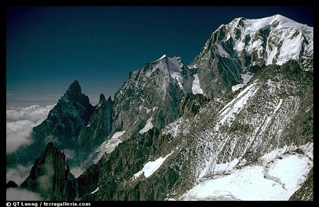
This is a special introduction to the
mountains and prominences of France, provided to peaklist.org by Mark
Trengove.
Introduction
France is a large country by European standards. It has an area
of 549,619 square kilometres (212,209 square miles) and has a
population of around 61.1 million (2002).
With the exception of the Massif Central in south central France and
the Island of Corsica in the Mediterranean Sea, the mountainous regions
of France can be found on or near the eastern and southern borders of
the country. To the north and west of the Massif Central the land
is mainly flat and low-lying, although the peninsula of Brittany
jutting into the Atlantic Ocean presents a rugged granite coastline and
an interior reaching an altitude in excess of 300m (1000 feet) in
places.
Two main geological events have given rise to the upland areas of the
country. The first was the Hercynian Orogeny (=
mountain-building), which occurred at the end of the Palaeozoic Era
(c.300 to 248 million years ago). This created the Hercynian
Massif, which stretched across much of the land that was to become
Europe. The other event was the Alpine Orogeny, which occurred in
the middle of the Tertiary Era (c.50 to 40 million years ago).
This was responsible for the uplift of the Alps, Pyrenees, and
mountains of Corsica. It also created the folding of the Jura and
the faulting of the remains of the Hercynian Massifs (the Vosges and
Massif Central), and a volcanic outbreak to the centre and east of the
Massif Central. Between these periods of orogeny, erosion wore
down the rocks, depositing material in the seas and lakes which had
formed between the mountain ranges.
Today there are the remains in France of four parts of the Hercynian
Massif (Brittany, Vosges, Massif Central and the tract of high ground
connecting the latter two). In between these blocks of hard
granite, sandstone and shale are sedimentary basins linked by lowland
corridors. To the south-east and south-west lie the much younger
and higher folded mountain ranges of the Alps, Jura and Pyrenees.
The French Alps
The French Alps form the western flank of the great mountain arc
of
some 800 km (500 miles) that stretches around the northern perimeter of
Italy. The countries of Slovenia, Italy, Austria, Liechtenstein,
Germany and Switzerland, as well as France, all share in this, the
biggest and highest mountain chain in Western Europe. The range
contains many mountains over 3000m (9,800 ft) in Austria, Italy,
Switzerland and France. There are also a large number of peaks
over 4000m (13,100 ft) in Switzerland, Italy and France. The term
‘Alps’ was first applied to this range, but was later used for other
mountain ranges in the world (the Australian Alps, for example).
The French portion of the range includes the highest summit in Western
Europe – Mont Blanc at 4808m/15,774ft altitude.
The French Alps were pushed up against the Massif Central block to the
west during the Alpine Orogeny. They are folded and overthrust
mountains, sharpened by frost and eroded by glaciation and running
water. There are two main types of rock structure. The
central core of the High Alps is composed of Palaeozoic crystalline
rocks, with violently folded metamorphic rocks around the edges of the
core area.
The French Alps can be divided into four geological sections, all
running in parallel on a mainly north-south orientation:
• The High Alps. This section is about 100km (60 miles) in width,
and mainly follows the Franco-Italian border. The High Alps are
structurally very complex, especially in the south-east, with folding,
overthrusting and nappe formations. Crystalline massifs form the
highest ranges. These ranges are composed of a great variety of
rocks, including granite, gneiss and schist. The highest summits
are found here, particularly in the Mont Blanc and Écrins
Massifs.
• The Longitudinal Trench. This is composed of the vale of
Chamonix and the valley of the River Isère between Albertville
and Grenoble. It is only about 5km (3 miles) wide and is several
thousand metres lower than the mountain ranges which flank it.
The trench is formed of soft shale, rapidly eroded by the fast-flowing
rivers that drain the mountains around it.
• The Pre-Alps. These ranges stretch from Lake Geneva to
the River Durance. They are composed of limestone and are
generally half the altitude of the High Alps. They are bisected
by four main cluses (deep valleys with steep sides) which once held
rivers but now contain large lakes such as Lake Annecy.
• The Alpine Foreland (The Dauphiné). This area lies
between the Rivers Isère and Rhone at the western foot of the
Pre-Alps. It is mainly covered in deposits of pebbles and clay
washed down from the Ice Age glaciers. There are moraines, rock
basins and outwash material which have been terraced by the action of
rivers.
The French Alps have been, and are still being, moulded by glacial
action. The High Alps were much affected by the Écrins ice
cap in the last Ice Age. The ice flowed south and then west down
the valley of the Durance. After the ice ages, vast amounts of
meltwater flowed west and south off the melting ice caps for hundred of
kilometres to the Mediterranean Sea. As the weight of ice lifted
off the mountains, they rose in altitude. They are still rising
to this day, although the rate has slowed to the extent that they are
being eroded as fast as they rise. Glaciers still exist today,
but they are receding rapidly as global warming takes place. The
glaciers today are valley glaciers like the Mer du Glace below Mont
Blanc, or cirque or niche glaciers.
The highest, and most prominent mountains in the French Alps are Mont
Blanc itself (4808m/4695m, 15774ft/15403ft) and Barre des Écrins
(4102m/2045m, 13458ft/6709ft).
The Jura range straddles the border between France and
Switzerland. It begins in eastern France on the northern bank of
the River Rhone and then extends northwards along the northern bank of
that river and Lac Léman (Lake Geneva) to the Swiss frontier
north of Geneva. From that point it continues as the boundary
line between France and Switzerland in a long arc curving to the
north-east. The range eventually passes wholly into Switzerland,
ending on the southern bank of the Rhine near Basel. The range is
some 320 km (200 miles) in length, and between 32 km and 56 km (20 to
35 miles) in width.
The limestone of which the Jura is formed was laid down in shallow seas
of the Jurassic period (205 to 145 million years ago). It is rock
rich in fossils. Indeed the range gave its name to this period in
the Mesozoic Era. The range consists of a series of parallel
folds in the strata forming a high plateau. The folded ridges are
cut by transverse fractures which in places form steep gorges
(cluses). The effects of glaciation can also be seen,
particularly on the more steeply scarped southern flanks of the
range. The glaciers have long gone from the range, however, and
there is now no permanent snow.
The range was originally mainly forested, even to its lower
slopes. Today the upper slopes remain forested (apart from the
highest summits which are open grassland) but the action of man has
stripped the middle and lower slopes of their forest cover to leave
pasture.
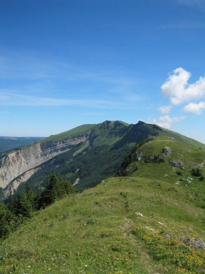
The general altitude of the Jura is between 910m and 1520m (c.3000ft to
5000ft). The range reaches its highest point near the
south-western end of the range in France at Le Crêt de la Neige,
which has an altitude of 1718m and prominence of 1268m
(5636ft/4160ft). The highest and most prominent summit of the
Bernese Jura in Switzerland is Chasseral at an altitude
of 1606m and prominence of 666m (5269ft/2185ft).
Image: View south along the
main ridge of the Jura to le Crêt de la Neige
The French Pyrenees
The Pyrenees, which straddle the Franco-Spanish border and take
in the
tiny independent state of Andorra, stretch
from the shores of the
Mediterranean Sea in the east to the Bay of Biscay on the Atlantic
Ocean in the west. The chain extends in a relatively straight
line from east to west to a total distance of 435 km (270 miles).
It reaches a maximum width of c.130 km (80 miles). Its total area
is 55,374 square km (21,380 square miles). Two thirds of this
area lies within Spain.
The range was thrust up in the Tertiary Period (66.4 to 1.6 million
years ago). It consists of three parallel lines - a ‘sandwich’ of
softer rocks, with a very tough granite centre in between. The
high uplands consist of exposed crystalline rocks, while folded
limestone composes the lower slopes. These features give rise to
flat-topped massifs and folded linear ridges. The range was
extensively glaciated in earlier times, giving rise to impressive
glacial valleys and cirques, particularly on the French side. The
glaciers have now nearly gone, but permanent snow can often be found
above c.1800m (6000 ft) on north-facing slopes.
The French side of the range presents much steeper inclines than the
southern Spanish side, with spectacular torrents called gaves fed by
the generous rainfall. The southern slopes provide a drier
steppe-like climate.
The range reaches its highest point on the Pico de Aneto at 3404m
altitude and 2812m of prominence (11168ft/9226ft). This mountain
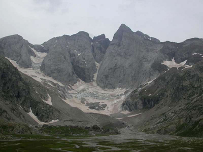
lies wholly within Spain. The highest summit in the French
Pyrenees is Pic de Gran Vignemale (3298m/1025m, 10821ft/3363ft) on the
Franco-Spanish border.
Image: Pic de Gran Vignemale
(right) – the highest summit in the French
Pyrenees
The Massif Central
The Massif Central is the only mountainous region of mainland
France
which lies wholly within the country. It covers one sixth of its
surface area of France. On the northern side it is bounded by the
Paris Basin, on the eastern and southern sides by the Rhone Valley and
delta, and by the Aquitane Basin in the west. It is roughly
circular in shape, with an area of around 93,000 square km (36,000
square miles) and an average height of 715m (2300ft). It is the
most geologically diverse area of France and also has the most varied
climate.
The massif is made up of four main areas:
• Limousin.
This region lies on the north-western side.
This is soft more undulating country of green pastureland, ranging in
altitude between 300m (1000ft) and 1000m (3300ft). It is composed
of crystalline rocks.
• The Auvergne.
This is the central area containing the majority
of the highest summits in the massif. To the east lie the
mountain ranges of Forez, Livardois and Velay. To the east are
the remains of extinct volcanoes – the Monts Dômes, Monts Dore
and the Monts du Cantal. The fertile soil and high rainfall makes
the area a region of lush pasture and forest. There are also many
crater lakes.
• Aveyron.
This area lies to the south-west. The waters of
the rivers Lot, Aveyron and Tarn flow westwards through this region
from the Aubrac mountains. It is an area of deep gorges and
valleys with dry plateaux above.
• Lozère.
This is the region in the east of the
Grands Causses of the Cévennes. It is a vast dry isolated
upland composed of granites, gneiss, limestone and schists.
The massif was raised up again in the same period as the formation of
the Pyrenees and the Alps (the Alpine orogeny) by a counter-movement
that crushed the sedimentary rocks of the area up against the hard
granitic blocks, causing faulting and rifting. This gave the
massif an east-west incline, with the highest areas lying to the east
nearer the Rhone Valley. Volcanic activity continued beyond the
Tertiary Period until as recently as 8000 years ago. Glaciation
further shaped the area, covering most of the region in an icecap which
must have resembled Iceland today. The volcanoes were remodelled
by the glaciers into a landscape of ridges, deep valleys and
planezes. There is now, however, no permanent snow.
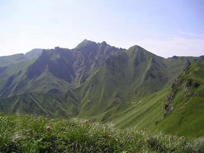
The highest and most prominent summit in the massif is Puy de Sancy in
the Auvergne, which has an altitude of 1885m (6184ft) and prominence of
1578m (5177ft). The second most prominent summit in the Massif
Central is Mont Mezenc in the Ardèche (south-east area) which is
1753m in elevation and c.793m in prominence.
Image: Le Puy de Sancy
– highest summit in The Massif Central
The Vosges
The Vosges range stretch along the west bank of the River Rhine in a
NNE direction from north of Basel in Switzerland to nr. Mainz in
Germany
for a distance of 250km (150 miles). Most of the range, including
all the summits of 915m (3000ft) and over, is situated in France.
The range forms the west flank of the Rhine rift valley, while the
Black Forest in Germany, of similar latitude and geological
formation, forms the east flank.
The range is divided into four sections, which are from south to north:
• The Grandes Vosges,
some 100km (62miles) in length, extending from
Belfort in the south to the valley of the Bruche. The rounded
summits of this area are called ballons. Their average altitude
is around 1100m (3600ft).
• The Central Vosges,
extending from the Bruche to Saverne for 50km (31
miles). The summits here tend to be narrower and more
pointed. Their average altitude is around 900m (3000ft).
• The Lower Vosges,
extending from Saverne in France to the source of
the Lauter for 48km (30 miles). The average altitude of the
plateau is around 500m (1600ft).
• The Hardt,
wholly in Germany.
In their southern sections the Vosges are mainly of granite formed in
the Carboniferous Period (354 to 290 million years ago) laid down on a
bed of gneiss dating from the Pre-Cambrian Period (2800 to 545 million
years ago). There are also some porphyritic masses. Further
north the plateau is mainly of red sandstone. These rock
formations were lifted up around 50 million years ago during the Eocene
Period as part of the same mountain forming period that created the
European Alps. During the Quaternary Period (2 million years ago)
the western side of the range developed an ice plain, while on the
eastern side, which is much steeper, small glaciers carved out the
typical glacial features which can be seen today in the Grandes Vosges.
The lower slopes are now deforested, but higher up there is extensive
forest on all but the highest summits, which are open grassland.
The western side of the range receives most of the rain/snowfall and
has a much lower mean temperature. Vines grow on the eastern
flanks of the range up as high as 400m (1300ft). There is no
permanent snow on the range.
The range reaches its highest point on Le Grand Ballon de Guebwiller at
the southern end of the range, which is 1424m (4672ft) in altitude and
1072m (3517ft) in prominence. The second highest summit is Le
Hohneck (1362m/4468ft in altitude). Although this summit is over
25km (16 miles) along the ridge from Le Grand Ballon, it is only
186m/610ft in prominence.
Image: Le Hohneck –
second highest summit in the Vosges
Mountains of Corsica
The island of Corsica lies some 180km (112 miles) south of the
main
French coast in the western half of the Mediterranean Sea. It is
the third largest island in the western Mediterranean. It has the
loftiest mountains and more rivers than any other Mediterranean
island. The rugged coastline extends for over 950km (600
miles). Twenty-one of its mountains are over 2000m
(6500ft). The average altitude of the island is 560m
(1800ft). The mountains run in a general south-east to north-west
direction, cutting the island in two.
There are four main massifs:
• Cinto:
This range lies on the north-western side of the
island. The mountains are very rough and broken. They are
formed of granitic rocks – mainly volcanic rhyolites. The range
has the highest summits on the island.
• Retondo:
This range lies in the north central region of the
island. This area is also composed of granitic rocks and is very
uneven. There are several glacial lakes. It reaches its
highest point at Monte Retondo (2625m/8612ft).
• Renoso:
This range lies in the south central region of the
island. It is also mainly composed of granite, but is a less
dramatic landscape. Monte Renoso is the highest point of the
range at 2357m/7733ft.
• Incudine-Bavella:
This range lies in the southern part of the
island. It is also mainly granite, but with limestone as
well. The landscape varies from undulating to jagged peaks like
the Aiguilles de Bavella. The highest summit is the Incudine at
2136m/7008ft.
There are also mountains of lesser altitude on the north-eastern side
of the island and on the Cap Corse Peninsula in the far north.
The mountains of Corsica are geologically part of the mainland Alpine
system. Their granite backbone was laid down some 250 million
years ago. These rocks were raised in the Alpine period of
orogeny some 50 million years ago. On the eastern side of the
island a mass of sedimentary rocks was pushed up against the granite,
becoming a folded metamorphosed bed of hard resistant schists. As
on the mainland, glaciers carved the ranges into sharp crests and
ridges, and deep valleys. Extensive rainfall changed the glacial
valleys into V-shaped form.
There is now no permanent snow, or glaciers – although snow can lie on
the highest summits into May despite their southern latitude.
Above the areas of cultivation and deciduous and pine forest, the mid
level of the mountains is covered in maquis – harsh resilient bushes
like broom, gorse and myrtle. The highest areas have an
Alpine climate and vegetation.
The highest mountain on the island is Monte Cinto. This has an
altitude of 2706m/8878ft and equal prominence.
Image: Monte Cinto
Range, courtesy of www.lavaurs.com/en/etapes
Hiking in the mountains of France
In France there is a general freedom to roam on all open paths and
tracks, and across the high slopes of the mountains. In practice
there is little need to go ‘off path’ because a complex network of good
paths serves valleys and mountains. The main routes are called
Grandes Randonées and given numbers (e.g. GR5).
Most of the mountainous areas of France are provided with mountain
refuges. Some of these are owned by French mountaineering clubs
(e.g. Club Alpin Français), while others are in private
hands. Some are open throughout the year, while others only in
the warmer months. Many have a resident warden. Many will
be able to provide food and drink to their guests. Telephone
numbers of the refuges will be available at local tourist
offices. Many refuges in popular areas are booked out many weeks
in advance.
Maps
France is a country excellently mapped. The best maps are
produced by the Institut de Géographique National (IGN) (website
at www.ign.fr). There are maps for the whole country at both
1:100,000 and 1:25,000 scales. For the greater ranges (Alps,
Pyrenees and Corsica) the 1:25,000 scale maps have been employed to
produce these lists, while 1:100,000 scale has been mainly used for the
lower ranges (Vosges, Jura and Massif Central).
The lists give both coordinates (longitude/latitude) and French grid
references, which are centred on Paris as referencing point.
Guide books
An excellent selection of hiking and climbing guides in English on the
French mountain ranges (and elsewhere in the world) are produced by
Cicerone Press, a UK publisher. Their website is at
www.cicerone.co.uk.
The Lists
The lists, which will be added in forthcoming months to this section of
www.peaklist.org, aim eventually to cover all the mountain summits on
the French
mainland and Corsica that are both 150m of prominence and 910m
(3000 ft) in altitude. These summits have been nicknamed ‘les
Bardots’, seeing that the habit of naming mountain lists after
glamorous female film stars has caught on on the other side of La
Manche (the English Channel)!
Why 910m/3000 ft? Selecting this altitude to determine the
mountainous areas of France works well. It removes the areas of
the country that are certainly hilly but could not be classified as
mountainous – in particular the large arc of high ground that connects
the Vosges with the Massif Central.
You will note that the lists actually go down to 140m of
prominence. The mountains between 140m and 149m form the
‘Sub-Bardots’. They are included because altitudes given on maps
are likely to be accurate to +/- 10m, which means that some of these
summits may really be Bardots (and, conversely some Bardots may be
Sub-Bardots).
Hiking/climbing the mountains on these lists vary in difficulty from
easy strolls to difficult multi-day ascents in which the full panoply
of mountaineering skills will be needed. There are, for example,
nine summits in the lists of 4000m (13100 ft) or over in
altitude. All these have extensive permanent snow cover, as do
many of the lower summits. Climbing all the Bardots will
therefore represent a very considerable undertaking.
The lists do, however, present some enticing objectives for mountain
walkers who do not wish to become full alpinists. There are many
summits on the lists of significant prominence that merely involve
putting one foot in front of the other.